Text to Image
Detailed Physical World Map with Info Panels — AI Image Prompt
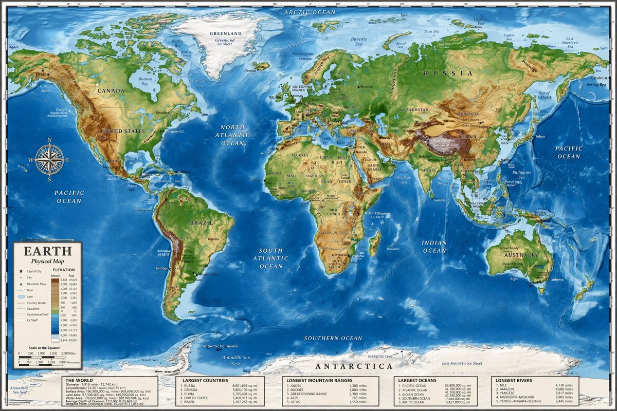
Generates a highly detailed topographical world map featuring a legend, compass rose, and five informational data panels at the bottom. - AIPinMaker
Prompt
{
  "type": "highly detailed cartographic world map",
  "style": "{argument name=\"color palette\" default=\"realistic topographical and bathymetric colors\"}",
  "map_features": {
    "terrain": "shaded relief showing mountains, valleys, and plains in greens, browns, and whites",
    "oceans": "depth shading in various tones of blue, with lighter blues for continental shelves and darker blues for deep trenches",
    "grid": "latitude and longitude lines spanning the entire map",
    "labels": "major continents, countries, oceans, and seas clearly labeled in serif and sans-serif typography"
  },
  "layout": {
    "overlays": [
      {
        "type": "compass rose",
        "position": "mid-left, over the Pacific Ocean",
        "description": "classic 8-point nautical compass"
      },
      {
        "type": "legend",
        "position": "bottom left",
        "title": "{argument name=\"map title\" default=\"EARTH\"}",
        "subtitle": "{argument name=\"map type\" default=\"Physical Map\"}",
        "contents": "elevation color key, map symbols, and distance scale"
      }
    ],
    "bottom_panels": {
      "count": 5,
      "position": "horizontal row along the bottom edge",
      "labels": [
        "THE WORLD",
        "LARGEST COUNTRIES",
        "LONGEST MOUNTAIN RANGES",
        "LARGEST OCEANS",
        "LONGEST RIVERS"
      ]
    }
  }
}Prompt breakdown
- Subject
- highly detailed cartographic world map showing shaded relief terrain ocean depth shading latitude longitude grid and labeled continents countries oceans seas
- Style
- realistic topographical and bathymetric colors with serif and sans-serif typography
- Composition
- mid-left 8-point compass rose over Pacific bottom-left legend titled EARTH Physical Map with elevation key and five horizontal bottom panels labeled THE WORLD LARGEST COUNTRIES LONGEST MOUNTAIN RANGES LARGEST OCEANS LONGEST RIVERS
Remix ideas
- swap the legend title argument to WORLD TOPOGRAPHY and change subtitle to Elevation Map
- increase ocean depth contrast by editing the color palette argument to deeper indigo trenches
- add a sixth bottom panel for deepest ocean trenches and reorder the existing row
Reference images

How to use this AI Image prompt template
 1
1Copy the prompt — grab this template’s prompt and negative prompt.  2
2Pick a model — choose a recommended AI model for the best match.  3
3Generate — open the studio with one click and create your result.
Related templates

Geographic Map Illustration
Create a creative image of Geographic Map Illustration. Style: photorealistic. Composition: balanced and well-framed. Lighting: natural with cinematic mood. Category: photography. Reference: geographic-map-illustration-14797.

Technical Breakdown Infographic
Create a infographic image of Technical Breakdown Infographic. Style: photorealistic. Composition: balanced and well-framed. Lighting: natural with cinematic mood. Category: illustration. Reference: technical-breakdown-infographic-24451.

Infographic Explaining Fibonacci Sequence with Math and Code
Create a cinematic image of Infographic Explaining Fibonacci Sequence With Math And Code. Style: photorealistic. Composition: balanced and well-framed. Lighting: natural with cinematic mood. Category: cinematic-video. Reference: infographic-explaining-fibonacci-sequence-with-math-and-code-1867.

Premium Pitch Deck Storyboard
Create a game image of Premium Pitch Deck Storyboard. Style: photorealistic. Composition: balanced and well-framed. Lighting: natural with cinematic mood. Category: illustration. Reference: premium-pitch-deck-storyboard-25540.

Exploded View Invention Infographic
2x2 grid, do this for tesla coil (invention) and 3 other famous inventions. 16:9 inventor_content = ( patent_drawing_recreation_in_isometric_exploded_view_of_[invention (invention placeholder)]_by_[inventor (inventor placeholder)] * 1.7 ) + ( historical_context_timeline_of_scientific_breakthroughs_leading_to_[invention] * 1.5 ) + ( failure_log_and_iteration_cards_showing_[inventor]_s_failed_prototypes_with_annotations * 1.6 ) + ( cross_section_and_mechanics_diagram_of_[invention]_with_material_callouts * 1.4 ) + ( economic_and_cultural_impact_ripple_map_of_[invention]_on_society * 1.3 ) + ( quirky_personal_habit_or_workshop_inserts_from_[inventor]_s_biography * 1.2 ) + ( modern_day_derivative_technologies_tree_from_[invention] * 1.1 ) + ( common_misconception_busting_panel_about_who_really_invented_[invention] * 1.0 ) - ( romanticized_lone_genius_cliché_without_team_context / 3.0 ) - ( boring_textbook_engraving_style_instead_of_dynamic_infographic / 2.9 ) - ( eurocentric_filter_if_invention_originated_elsewhere / 3.2 )3

3D Cutaway Volcano Diagram
A 3D cutaway diagram of a volcano, showing its internal structure. The diagram should clearly label the magma chamber, conduit, throat, crater, and layers of ash and lava. The style should be a clean, technical illustration, with realistic textures for the rock and magma. This demonstrates the ability to generate accurate, science-based visuals for educational purposes, requiring strong spatial and scientific reasoning. –ar 16:9
Explore more prompts
Browse more AI image and video prompts by category.
FAQ
- Which map elements can be customized via arguments in this prompt?
- The color palette argument controls land and sea tones while the map title and map type arguments let you retitle the legend and change its subtitle without altering the five fixed bottom panels.
- How do the bottom panels integrate with the main map?
- The five panels sit in a continuous horizontal strip along the bottom edge and supply supporting data on countries mountain ranges oceans and rivers that complements the labeled physical features shown above.